The people here are so friendly that while I was pulled off to the side of the road to take a few of these, a gentleman and his wife stopped to see if I needed help as they thought I had experienced car trouble. I hadn't, just shutterbugging, but I'm still amazed at the hospitality and friendliness of the people here. This is not uncommon in Tennessee as people are always quick to offer a helping hand to anyone in need. It's so nice to live in a place where people know how to love their neighbor. Tennessee, I hope you never change.
Sunday, December 14, 2008
Snow Capped Beauty & Good Neighbors in Chuckey, Tennessee
The people here are so friendly that while I was pulled off to the side of the road to take a few of these, a gentleman and his wife stopped to see if I needed help as they thought I had experienced car trouble. I hadn't, just shutterbugging, but I'm still amazed at the hospitality and friendliness of the people here. This is not uncommon in Tennessee as people are always quick to offer a helping hand to anyone in need. It's so nice to live in a place where people know how to love their neighbor. Tennessee, I hope you never change.
Friday, November 28, 2008
Margarette Falls Trail - Greene County
Margarette Falls Trail - Greene County, Tennessee
Margarette Falls Trail (aka Marguerite Falls) is located off Shelton Mission Road in the Bullen Hollow section of the Cherokee National Forest. The trail that leads to the magnificent 60-foot falls starts out on a wide graveled road with a gentle grade for about 1/2 mile. The trail splits to the left from Phillips Hollow Trail. It becomes a little more rocky and requires passing over the stream in four locations. There are several smaller falls seen along the way to the grand upper fall. The rocks and leaves can be slippery, so please use caution. This portion of the trail can be strenuous for the novice hiker and young children but the falls are well worth the climb. From the parking lot, Margarette Falls is approximately 1.2 miles with the last .7 being slower pace due to the terrain.
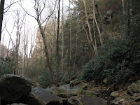
The trail follows the creek along the way.
Before you reach the 60-foot fall, look up and you will see the towering rock that forms the deep hollow which stands on each side of this beautiful creek and its multiple falls.
Monday, November 3, 2008
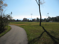
The Walking & Biking Trail in Greeneville, TN
Monday, October 27, 2008
Roan Mountain State Park, Roan Mountain, TN
Round Knob - Cherokee National Forest
Round Knob summit is located in the Cherokee National Forest and provides beautiful scenery of the surrounding mountains. Located in Greene County, TN, Round Knob highest peak is 3,258 feet (993.04 meters) above sea level. Round Knob is located at latitude - longitude coordinates of N 36.067049 and W -82.684867.
For detailed hiking information about Round Knob, view the topographic map and the Greystone USGS quad located here:
Nearby trails include the Appalachian Trail: Allen Gap to Devil Fork Gap, Hurricane Gap, Viking Mountain and the Appalachian Trail: Tanyard Gap to Allen Gap.


Tuesday, September 2, 2008
Kinser Park, Greeneville, TN
Kinser Park, established in 1974, is a 286 acre park leased to Greene County and the Town of Greeneville, TN. Below are pictures of the features Kinser Park offers.
Entrance to park.
Greeneville, TN Parks - Hardin Park
Subscribe to:
Posts (Atom)